

Surroundings
Sozopol offers its guests a rich history, medieval architecture, and excellent conditions for relaxation. But the attractions and interesting places to visit don’t end within the city limits. In close proximity, there are a number of fascinating cultural and natural landmarks:
The Islands
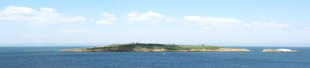
St. Ivan Island in Sozopol is a unique natural and cultural-historical landmark. The island is home to the largest colony of Mediterranean gulls in Bulgaria, as well as around 70 bird species listed in the Red Book of Bulgaria as endangered. St. Ivan Island has been considered a sacred place by every civilization that has inhabited the city.
St. Ivan Island is the largest of the five islands in the Bulgarian territorial waters of the Black Sea. It has an area of about 660 hectares. The island is equipped with a sonar lighthouse that emits sound signals and, together with the lighthouse at Cape Emine, guides vessels towards Burgas Bay. In 1993, the island’s territory was declared protected to preserve the natural habitats of rare and endangered bird species listed in the Red Book of Bulgaria, as well as the rare underground hare.
Right next to St. Ivan Island is its smaller sibling, St. Peter Island. It is also part of the protected territory. Its area is only 4-5 decares. It is known as the “Island of Birds” due to the characteristic light color of its cliffs, thanks to the birds inhabiting it. It is believed to have been separated from St. Ivan Island following a natural cataclysm since it is not mentioned in historical sources until the 9th century. Archaeological remains of ceramics from ancient times and remnants of a chapel from the Renaissance period have been found on the island.
The third island is named St. Kirik and is connected to the city by a breakwater. This way, the bay is enclosed like a horseshoe. In 1925, a fishing school was built on the island, and in the second half of the 20th century, it was converted into a Bulgarian naval base. In 1965, the island was declared a cultural monument and included within the boundaries of the Sozopol Reserve.
Beaches of Sozopol
Within the town, tourists can choose between the Central Beach of Sozopol and the “Harmani” Beach. The first one is smaller but quite secluded and suitable for inexperienced swimmers and children. It is located on the border between the old and new town. Harmani Beach features a long and wide sandy strip, but the seabed can be uneven in some places. On the way to Sozopol from Burgas, shortly after Chernomorets, there are the beaches of Gradina Camping and Zlatna Ribka Camping. These beaches have a wide sandy shoreline and a gently sloping seabed. To the south of Sozopol lies Kavatsite Beach, which includes the beach areas of Kavatsite Camping, Veselie, and Smokinya. This beach is home to the Sand Lily Reserve and a protected area with sand dunes.
Beglik Tash Thracian Sanctuary
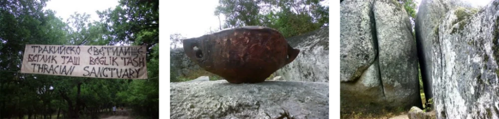
In 2003, the unique Beglik Tash Thracian Sanctuary was discovered, described as the earliest known Thracian megalithic sanctuary in Southeastern Thrace and along the Black Sea coast. Research conducted confirms that active human activity was already taking place here in the late Bronze Age (13th century BC). The sanctuary consists of a central part and two circles of smaller structures around it, with a total area of about 6 hectares. The largest stone measures 12 meters in height and 9 meters in length, resembling a womb and symbolizing the feminine principle according to archaeologists. It is believed to have been there for nearly 5000 years. The two circles have diameters of 80 and 120 meters, and they have not yet been fully excavated. The large rock fragments are partially carved by human hands and assembled on-site, while the stone slabs and blocks are arranged in unique formations. Stone circles, basins, and “Markov’s Steps” are carved into the flat rocks. Residential buildings and cult hearths complement the evidence of human activity in this area.
The Lion’s Head Rock Phenomenon
Located between the resort towns of Sozopol and Primorsko, the Lion’s Head is declared a natural landmark on May 13, 1947, covering an area of 70.5 hectares. It is an impressive rock formation with the shape of a lion’s head, carved into the syenite rocks near the Ropotamo River.
The Agalina Cape Rock Phenomenon
Interesting rock formations with specific coastal vegetation and wildlife. It is situated near the town of Sozopol and was designated as a natural landmark on December 30, 1980, covering an area of 31 hectares.
Ropotamo Reserve
Located between the resort towns of Sozopol and Primorsko, Ropotamo Reserve was declared a reserve in 1992, covering an area of 1000.7 hectares. The area around the flow of the Ropotamo River was declared a reserve in 1940. The status of the area was changed to a national park in 1962. In the following years, the ecological balance within the park was disrupted due to uncontrolled tourist activities. The nature was polluted due to intensified construction. As a result, Ropotamo became the most endangered protected territory in Bulgaria. In order to preserve the nature of the reserve from further damage, in 1992, the status of Ropotamo was changed to a strict regime reserve.
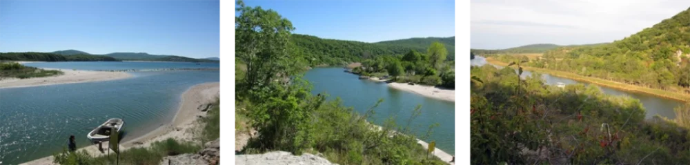
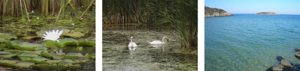
The Estuary of the Ropotamo River is one of the main tourist attractions in the reserve. In the estuary area, the river is calm and deep. The shores are covered with dense riparian forests, with numerous lianas growing among the trees. Water lilies and reeds grow in the shallower sections near the shores and in areas where backwater lakes have formed.
Of particular importance to the reserve is the presence of sea holly, one of the largest populations of this plant in Bulgaria. Over 100 plant species found within the reserve are listed in the Red Data Book of Bulgaria. The reserve is also significant from an ornithological perspective, with 257 bird species occurring within its boundaries, 71 of which are listed in the Red Data Book of Bulgaria. Eight bird species considered globally threatened can be found here.
The rock formations in Ropotamo Reserve are mainly coastal, including sand dunes, rocky cliffs, and steep terraced shores. The flora and fauna include rare and endangered species. Within the reserve’s territory, there are several smaller designated reserves.
Arkutino Reserve
Located at the mouth of the Ropotamo River, Arkutino Reserve is a protected area since 24th July 1962, covering an area of 96.6 hectares. It is a botanical reserve within a riparian forest, with water lily habitats. The reserve features a small lagoon swamp called Arkutino, situated 2.5 km northwest of the Ropotamo River’s estuary, in the northern part of the Ropotamo Nature Park. Separated from the sea by a sandy beach and dunes, Arkutino was formed during the sinking of the Black Sea coastline. During dry periods, Arkutino almost completely dries up. In 1962, Arkutino and the surrounding riparian forest were declared a reserve. Arkutino is notable for its water lilies, reeds, and cattails that cover it almost entirely. The reserve is a nesting site for waterfowl and serves as a resting base for many migratory birds.
Water Lily Reserve
Located near the mouth of the Ropotamo River, the Water Lily Reserve is a protected area since 24th July 1962, covering an area of 13.6 hectares. It is one of the four reserves situated within the boundaries of the Ropotamo Nature Park. The reserve is renowned for its large water lily and bogbean populations, which grow amidst a longoz forest. Despite being part of the nature park, the reserve remains under the designated regime for all reserves, with limited access. Visitors can enter via a specially constructed wooden bridge, where they can admire the abundant growth of beautiful water lilies. Their beauty attracts both local and international nature enthusiasts.
Sand Lily Reserve
Located south of the town of Sozopol, the Sand Lily Reserve was declared a protected area on 31st August 1962, covering an area of 0.6 hectares. The reserve is characterized by having the largest deposit of sand lilies in Bulgaria. This plant arouses great interest among tourists and nature lovers due to its delicate flowers with a strong fragrance. Locally, it is also known as the “sand cream” or “sand fairy.” Due to its unique habitat and rare beauty, some refer to the sand lily as the “queen of the sands” or simply the “flower of the dunes.” Unfortunately, this intriguing plant is gradually declining, and in order to preserve the remaining small deposits, it has been protected under the Law on Nature Conservation since 1961. The sand lily blooms in July and August, with rare, snow-white and delicate flowers that evoke genuine admiration. Due to the continuous decline of this beautiful plant species, further efforts are needed for its conservation.
Snake Island Reserve (St. Thomas)
Located at the mouth of the Ropotamo River, Snake Island Reserve is a protected area since 1962, covering an area of 1 hectare. It is a small island situated near the shore of the sea, close to the Ropotamo Nature Park. The name “Snake Island” comes from the water snakes that inhabit it. The island is uninhabited and serves as a refuge and nesting base for various birds, including river kingfishers, silver gulls, wild ducks, and others. Years ago, cacti of the species Opuntia ficus-indica (a South American species) were transplanted and planted here. They have found a favorable environment, reproduced, and developed in the open in their natural habitat.